
TUDOR GOLD Corp. (TSX.V: TUD) (Frankfurt: TUC) (the “Company” or “TUDOR GOLD”) is pleased to report on results from its 2017 drill program on the Copper Belle zone of the Company’s Treaty Creek property in north-western B.C.
CB-17-12, a step-out hole drilled on the Copper Belle zone, intersected various mineralized zones where the most significant was 90.5m of continuous mineralization grading 1.21 g/tonne gold from 24 to 114.5m depth, including a higher grade intercept of 70.5m grading 1.47 g/t gold from 31.5 to 102m. Hole CB-17-12 was a 564m hole that was collared adjacent to the west side of the Treaty glacier where ice ablation (glacier melt-back) has exposed new opportunities for exploration access. Hole CB 17-12 is 110m south of CB-16-03 that graded 1.11 g/t Au for 58m from 88 to 146m; and 0.97 g/t Au for 122m from 304 to 426m. Hole CB 16-03 was drilled uphill at a higher elevation (see map).
Drill results for hole CB-17-12 summary
| Hole-ID | From (m) | To (m) | Interval (m)* | Au (g/t) | Ag (g/t) | Cu (%) |
|---|---|---|---|---|---|---|
| CB-17-12 | 24.00 | 114.50 | 90.50 | 1.21 | 4.22 | 0,016 |
| including | 31.50 | 102.00 | 70.50 | 1.47 | 5.26 | 0,018 |
| 147.50 | 198.50 | 51.00 | 0.84 | 3.44 | 0,019 | |
| 206.00 | 228.50 | 22.50 | 1.05 | 0.66 | 0,004 |
*True widths of the mineralization have not been determined.
Walter Storm, President and CEO, stated: “We are delighted to start the New Year with additional encouraging results from our 2017 exploration program at Copper Belle. The long intercepts of gold/silver mineralization starting near surface, continue to demonstrate the pervasiveness of this gold system with excellent grades to date that are open at the south and north extensions. More assays have been received and should be available within one week.”
The Copper Belle 2017 resource delineation program comprised 27 drill holes to depths below 700m (an estimated 13,722m) and step-outs of 50m where topography permitted. Results from additional drill holes of the 2017 drill program at Copper Belle are still pending. Drill holes were targeted oblique to the northwesterly plunge of the main mineralized zone. A block of delineated mineralization will form the basis for a preliminary resource estimate. All drill holes were down hole surveyed at 25m stations using a Reflex Multi-shot device.
The Company’s 2016 Magnetotelluric Geophysical Survey program (MT Survey) was effectively utilized as a guide for the drill program. The MT Survey suggests that the mineralization continues to the southwest, toward the Iron Cap deposit of Seabridge Gold Inc. The MT Survey also suggests that the mineralized zone is open along strike and to depth. TUDOR GOLD’s 2017 drill program was located five kilometers north of the Iron Cap deposit and the Company intends to step out to the south in its 2018 program to see if it confirms a relationship between the two areas.
Drill hole samples were assayed by Activation Laboratories Ltd. in Kamloops, BC. Analytical accuracy and precision are monitored by the submission of blanks, certified standards and duplicate samples inserted at regular intervals into the sample stream by TUDOR GOLD personnel. Activation Laboratories quality system complies with the requirements for the International Standards ISO 17025: 2005.
The Qualified Person for the Treaty Creek results in this new release is James A. McCrea, P.Geo. for the purposes of National Instrument 43-101. He has read and approved the scientific and technical information that forms the basis for the disclosure contained in this news release.
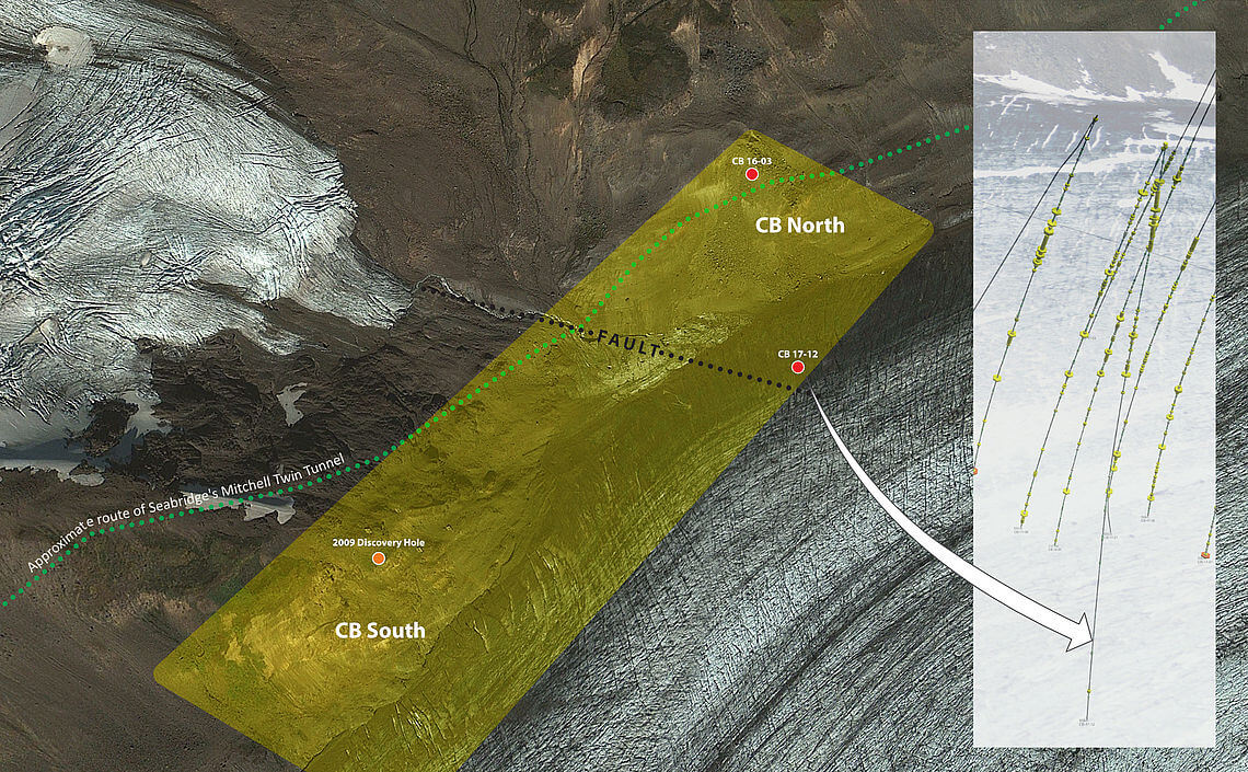
Copper Belle location map at Treaty Creek
Contact Information
Barry Holmes
Investor Relations
Phone:778-587-2074
Email:bholmesmba@gmail.com
Cathy Hume
CHF Capital Markets
Phone:416-868-1079 Ex 231
Email:cathy@chfir.com